“Cynical of
Bishopstoke”: “Don’t say I didn’t tell you so!”
(A resident of Bishopstoke for 45 years)
So, it would seem the so called Lib/Dems, the totally
dominant party upon Eastleigh Council, are up to there usual old tricks
again!
They called the initial consultation “The Draft Local Plan”, a
redraft of 3 previous failed efforts by the local Council over the past
20 years to formulate a Local Forward Plan, and at
relatively short notice Eastleigh residents were informed that they had
to have their written objections/considered opinions into the Council
Planning Officers by the 17th of February 2016. Proposals
within the Draft Plan of the greatest concern to residents of
Bishopstoke were under the heading B. & C.: a new road, Mortimer’s
Lane, Fair Oak, via ‘The Fox & Hounds’, across the Itchen Valley flood
plain, crossing Church Lane, linking to a straightened B3335 at
Highbridge, through, and under Allbrook rail arch, then after the
demolition of 3 properties at the foot of Pitmore Road, north west to
link to the motorway: these proposals to include the building of
some 5000 new builds to the north of Stoke Park farm, Bishopstoke,
on a flood plain, in one of the most beautiful green
belt areas in the Eastleigh Borough! The resulting ‘feedback’ from
Eastleigh Residents regarding these proposals: ….
Hundreds objected & 4 residents in favour!!
So, one would therefore presume that Eastleigh Council
Cabinet, led by Keith House, will heed the wants and opinions of the
majority of local residents, and reject B. & C. when they consider the
recommendations of their Planners upon the 16th of June??
Well, this is where I have to make a somber prediction, and say that
they will not only endorse options B. & C., they will favour options B.
& C. and include them in their final Local Plan submissions to the
Government Inspector in 2017, in fact I will go further, and say that
the Lib/Dems. , in conference, as early as October 2015, had already
taken a Lib/Dem policy decision to favour Options B. & C. amongst
themselves, as the controlling group upon the Borough Council!!!!!!
Why do I think this to be the case?
In 2015 a local resident forwarded copy documents for my
viewing: sourced from Highwood
Group based in Romsey,
Hampshire, ...” Experts in land
procurement, development and assembly”: these documents detailed land
that they had been instructed to procure on behalf of developers in the
area of Bishopstoke, Fair Oak, Highbridge/Allbrook : i.e. potential
development land. It is not coincidental that
the land indicated in these documents covered the entire area as
detailed under the Council’s Forward Draft Plan B. C.!!!
So, why would a company, and their
associated developers, risk investing huge sums of money in taking an
‘option on what they see as being potential building land’, unless they
had been given an indication that their investment was likely secure and
low risk? That advise can have only come from one source: Eastleigh
Borough Council, or their Planning Department; if only by casual
observation and reference!!
The Lib/Dems. Will now cry “Foul” and
voice their protestations, so truth or false?
Bishopstoke Farm in Bishopstoke Lane, and all of its associated
land, was sold to a developer five weeks ago, as being potential
building land under the Council’s Forward Plan Options B. & C.??
Stoke Park Farm
has already negotiated financial options with developers to sell large
tracts of land immediately North of Stoke Park woods to Upper Barn
copse, and further land, north of the farm house towards Colden Common,
land which fully embraces the Council’s Forward Plan Options B. & C.??
Highbridge Farm
which has land holdings in Church Lane, is already in negotiations with
both developers and Winchester Council, with a view to the sale of land
to accommodate the new road access to Highbridge under Options B. & C.,
and the straightening of the road: B3335 to the Allbrook railway arch??
So it would appear that the ,so called ‘Public Consultation of The
Eastleigh Draft Forward Plan’, was in fact something of a shameful
façade: a truth which only time will prove or disprove, resulting from
decisions the Council decides to make upon the 16th of June
2016: it will be interesting to see if this Council will even heeds
advise from their own Planning Officers!
Of further interest: the Stoke
Residents Association asked all Borough candidates standing for
Bishopstoke in the forthcoming May elections, to indicate their stance
regarding Options B. & C. contained in the Draft Forward Plan, as it
greatly effects the future of Bishopstoke, and the maintenance &
protection of its ambiance & surrounding countryside. Interesting:
several candidates have responded, and all have to date voiced their
total opposition to Options B. & C.: ‘no
comment’ from the Lib/Dem. Candidates to date………. One has to wonder
why???????
Three years ago writing as ‘Cynical of
Bishopstoke’, I predicted correctly the Borough Council’s stance
regarding both The Bellway & Cemex development proposals in Bishopstoke:
both developments were voted through by the Borough Council, despite
majority resident opposition. Regarding Options B. & C. of the Draft
Local Plan: I expect my predictions to be proved correct yet again, for
this Borough Council will “sell its soul to the devil, or should I say
developers’, if the ‘price is right’, whilst casting a cynically
ambivalent sneer to residential opinion: those very people who made the
mistake of electing these Lib/Dem. Councillors in the first instance!
Residents of Bishopstoke, we are now
relegated to only being able to show our displeasure with our local
council at the ballot box upon the 5th of May. I urge
residents not to waste this opportunity: caste your votes in these
elections aside from political dogma & bias, and vote for candidates in
your wards of Bishopstoke who sincerely undertake to represent the
views of the local residents in future, and to not simply to follow that
of their political masters!!
Still: “Cynical of Bishopstoke!” in
2016.
Jim Saunders 16th February 2016
People
of
Eastleigh.
it
seems
that
a
huge
number
of
us
stand
united
against
the
ever
increasing
number
of
developments
that
are
now
being
passed
through
by
our
Council
despite
ever
increasing
objection.
Our
LibDem
Councillors
have
stopped
listening
to
us
the
people
and
continue
to
approve
developers
planning
applications
without
regard
for
infrastructure
or
local
wildlife.
Many
residents
letters
to
the
new
Conservative
MP
Mims
Davies
have
gone
unanswered
and
it
seems
this
mass
house
building
is
the
result
of
collaboration
between
Local
LibDem
Borough
Council
Leader
Keith
House
and
Conservative
County
Councillors.
There
is
only
one
way
this
situation
can
be
dealt
with
now.
That
is
for
the
people
to
join
together
and
rise
up
in
protest
against
this!
What
you
can
do.
1
Attend
all
Local
Area
Committees
in
your
area
and
show
the
Councillors
WE
MEAN
BUSINESS!
https://www.eastleigh.gov.uk/…/c…/local-area-committees.aspx
2
DONT
VOTE
LIBDEMS
Local Area Committees
eastleigh.gov.uk|By Eastleigh Borough Council
Sunday 31st January 2016
Hello there,
Like many residents, I am very
concerned by Eastleigh Council development
proposals, and that the impact is not known widely
enough.
Would you please send out the attached document via
your email distribution list.
Time is short due to 17th Feb deadline for comments.
I can appreciate that you might want to add to your
email that 'these are not the official views of the
Residents association' -- however this matter seems
important enough that your distribution list be used
to distribute these reasonable views.
Many thanks,
Robin, (Letter to The Editor follows)
Eastleigh Borough Council Local development plan – Make
comments only until
17th February 2016
.
See the full plan and make comments here --
https://www.eastleigh.gov.uk/lp36
Please photocopy this page lots, and give to everyone
potentially affected
Note the route of proposed brand new road link through
unspoilt countryside, shown as red line
This option includes thousands of houses in unspoilt
countryside on high ground visible for many miles
.
Option B –Expansion of Fair Oak and Bishopstoke to the
north/north-east with related development in Allbrook
village
Note: This is one of eight options that the Council has
identified in order to seek the views of the public. At this
stage the Council has not identified any preferred options.
(See also Option A and Option C)
Figure 6.3 Option B – Expansion of Fair Oak and Bishopstoke and
development at Allbrook
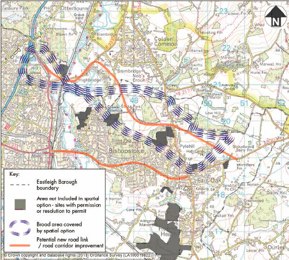
This option would destroy many bio-diversity habitats and be
visible for many miles from within the South Downs National
Park
If
this new road is approved it will in time be inevitable that
Fair Oak and Colden Common become joined up by housing.
This may all happen unless you and everyone you know
actually object, now.
Reasons why Option B is not acceptable
The North
Bishopstoke Bypass (NBB) is proposed to travel through
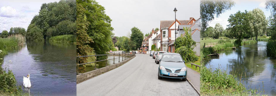
unspoilt countryside and Water meadows with lots of unique
rich bio-diversity in the river Itchen valley. This is a
rare and cherished chalk-stream habitat.
Species known to inhabit the many small ponds and streams in
this vicinity include - Otters,
Brown trout,
Atlantic salmon,
water vole,
great crested newt, king fishers and internationally
threatened invertebrate species - the native white-clawed
crayfish and the southern damselfly. The EU have made this a
Special Area of Conservation (SAC).
In winter
many species’ who normally habitat the margins of the flood
plain migrate temporarily to slightly higher ground, as the
flood plains saturates and the water table rises. This would
not be possible as Option B would have houses built on them.
Swans often
nest on the Itchen river just south, and just north of the
B3335 road at Highbridge, which will bring more traffic and
adversely impact their habitat. For example swans nest most
years on islands in the middle of the river just south of
Wardle road Highbridge. The extra noise and vibrations are
very likely to destroy this precious unique rare habitat.
The NBB will
bring a much greater risk of floods upstream, in an era
where we are told flooding and storms will increase.
The canal is
a rare feature here and would in due course have additional
bridges built over it.
The two NBB
options to Highbrige crosses the stream which flows from
east of main Road B3354. This stream has a catchment area as
far east as Gabriel’s copse and includes three quarters of
Colden Common. It flows westwards to near the dog and crook
pub, then south. This stream has flooded roads and
properties on numerous occasions, especially at Brambridge.
This problem let to the installation of very expensive flood
prevention solution which includes huge water storage tanks
and pumps south of eastern end of kiln lane.
The NBB here
crossing the flood valley of this stream would create a
blocking dam to water-flows in the shallow ‘valley’ of this
stream. Culverts, even several, would not solve the problem
created, of a road blocking the natural water flows within
the water meadows.
All of the
fields south of the dog and crook pubic house are absolutely
saturated in winter (as nature intended flood plains to be).
The crazy road proposal cuts straight across the valley of
this stream, and would have effect of creating a dam. Whilst
it’s possible from a civil engineering perspective to have
dozens of large culverts underneath the proposed road, this
will still leave a dam effect with water in the ground
trapped upstream of the road, and during heavy rainfall this
is very likely to lead to flooding problems upstream through
Brambridge and Colden common.
This would
mean the need to incur huge cost to upgrade that flood
system.
The dam
needed for the NBB across this stream would mean huge civil
engineering project which will cost the taxpayer a huge
amount of money.
Additionally
the existing B3335 Carriageway just north and south of its
main bridge across the river Itchen, already acts as a dam
across the river valley. This is particularly noticeable
just south of the bridge, where the roadway causes the land
to flood upstream extensively. The roadway also floods
already. As soon as additional traffic is diverted onto
this road, there will be a need to upgrade it (within a year
or less). The resultant civil engineering project will need
multiple additional big culverts under the road, in various
places across the flood plain in this area, along with
significant carriageway works. This will all be very
expensive for the tax payer.
Whilst all
the money for this massive civil engineering projects may
come from the developers and thus the householders of the
new houses, that means there will be far less money
available from the developers to fund community schemes for
all the new houses in this option, e.g. community centre /
facilities, schools, doctors surgery, etc. etc.
Additionally
there is also another small flood pump in Colden common
further up this stream, the increase in water table height
caused by the dam effect could undermine that capability,
and cause further flooding there.
The NBB road
will act as a siphon and bring lots of traffic off of the
M27 & M3. Traffic will be attracted to this route from the
huge conurbations of Fareham, Portsmouth, Gosport, hedge
end, and will travel via Bishops Waltham, Botley and Hedge
end northwards and join the new route in Mortimers lane or
crowd hill.
Additionally
traffic from the new houses to the north of Bishopstoke and
Fair Oak will also place a huge burden on - a/ the roads
through Colden Common and Twyford, and - b/ Down through
Church Lane and the mill at Bishopstoke, as people try to
reach Eastleigh and beyond. The houses associated with NBB
should be located elsewhere, the options in the southern
parishes do not have half as many problems as the NBB
option.
A huge
volume of traffic already travels north through this whole
area in the mornings, and south in the evenings.
Every time
there is a delay on those motorways traffic will naturally
try to follow this route. In the mornings when traffic on
this new route cannot easily get onto the M3 at Junction 12
at chandlers for north, these vehicles will turn north
through the two north – south roads through CC and onwards
through twyford. Whilst regulators may toy with the idea of
weight limits through Colden Common & Twyford, even if that
is successfully regulated (very unlikely) there will still
be a quadrupling of traffic volumes through these two
villages.
The whole
effect will be reversed in the evenings, with traffic
turning off M3 at J11 at Winchester, and trying to travel
south through twyford and Colden common, attracted by the
proposed new road.
I note that
on page 38 section 5.4.8 of the HCC Traffic analysis doc it
is acknowledged that traffic will increase by a significant
amount through Colden common and twyford – but no solution
is offered. I think we are all aware that this is because
there is no possible solution to traffic grid-lock problems
which will be caused at the western end of the “road to
nowhere”.
The road is
also bizarrely proposed to go through an 19th
century / 190 year old bridge, this has a height limit of
just twelve feet, and this will inevitably mean that lorries
hit the structure, or have to reverse in a very constrained
situation. Damage to the structure of the bridge may well
also lead to the closure of a main arterial rail route.
The proposed
long diversion for cyclists and walkers to cross under the
railway line is unacceptable. It’s lengthy, and will bring
personal safety issues in such a remote location.
The bridge
is also very narrow, it’s very likely that damage will arise
to the structure of the bridge due to lorries passing each
other under the bridge.
Any attempt
to provide greater headroom through the bridge by lowering
the road level underneath the bridge, will bring with it a
huge risk of undermining the foundations of the bridge
structure with the risk to services on this critical railway
line.
There is
already a dip in the road and a sump under bridge, this
floods and fills in heavy rain already – note the flood
markers on the sides of the bridge!
It would
need a major civil engineering project to build a suitable
pumping arrangement with an inherently expensive future
energy costs, to run the pumps.
All of the
fields in this whole area are saturated in winter, every
piece of roadway and road foundations will affect the
natural function of the flood plain
This option
has become known in Colden Common, Twyford, Allbrook and
Fair Oak as – “A road to nowhere”. It will create a
huge amount of extra traffic in Twyford, Kiln Lane, and on
Highbrige road, the latter two across the river Itchen. As a
strategic option this ‘Bishopstoke Bypass route is bonkers –
it will bring a lot of traffic to a point on Highbridge
road, which will inevitably lead to major increases of
additional traffic over the river Itchen on these two roads
– which will within a year of it being built lead to calls
for new bridges / widening on the B3335 and Kiln lane. Thus
the North Bishopstoke bypass option will build in major
middle term and long term civil engineering costs for the
tax-payer. Other options do not have such major financial
issues.
Whilst other
options have their constraints, any NBB option, by trying to
build a large road across a floodplain of the river Itchen
(and key tributary streams) will have an inherent civil
engineering cost which would not be anything like as large
with many of the other options, particularly those in the
southern parishes
The traffic
projections of an extra 2000 vehicles an hour on the NBB are
grossly underestimated -- every time there is any delay on
M3/ M27 motorways, a huge volume of extra traffic will use
the NBB and grid-lock all the roads in every direction from
the Highbridge end of the link road.
From a
strategic traffic management perspective any NBB route is a
very expensive option, and a comparative waste of tax payers
money which would be much better spent on other options.
By contrast
a better alternative route to relieve traffic in Eastleigh
and Bishopstoke is the southern bypass route. Whilst it
still has challenges, it will cross the Itchen valley at a
location adjacent to built-up industrial areas and the
sewage works. The Southern Bypass route would therefore have
much less impact on the environment, much less visual
impact, and would be a much better option for many other
reasons.
Comments on other options –
Option A
proposes a similar road as Option B, but with the north
westerly end shown ending at Highbridge, this would funnel a
high volume of traffic through Twyford and Colden common -
and I make the same comments as all of above.
Options for
housing and new roads in the southern parishes will be much
less expensive from an environmental and cost perspective.
______________________________________________________________________
Saturday 23rd January 2016
Eastleigh Borough Local Plan 2011-2036: Issues and
Options
With
apologies for the length of this comment.
Wednesday
20th January 2016 : viewing at The Community
Centre Bishopstoke.
Reaction.
I have seldom seen such a ‘hotch Potch’ Planning
presentation as a Proposal for a Local Plan.
The Presentation and its content reflects the past
inadequacies of Past Planning policy in the Borough, and the
fact that despite three local Plans having been drawn and
put forward over the past decade, the last was again
rejected by the Government Inspector! Current proposals now
reflect an almost ‘panic policy’ by Eastleigh Borough
Councillors and their Planners!
Dealing
with matters in priority in as much as it effects where I
live in Stoke Common Road, Bishopstoke. (Option B.)
This
option is impracticable, totally unfeasible, and will only
adds to the current road congestion, grid lock situation,
which everyone in the North, Central and Eastern Parishes
experiences at this present time.
Why is
Option B. being put forward in the first place? Simply
because the local Council, have already ‘shot themselves in
the foot’, by already authorising development in the area
designated under their supposed (Option C.) East of Fair
oak. Developers Drew Smith have already been granted
planning East to Mortimers Farm and will shortly start
construction. Land owners from Hall Lands to Pyle Hill,
Mortimers Farm, Stroudwood, north to the B2177 are currently
being offered £0.5Million per acre as potential development
land by developers, under the Councils proposed C.!!!! In
short, whilst Option C. is currently being promoted as a
proposal, in reality it is already a 90% certain development
in the eyes of the Borough Council. Now the Planners state
that this area will have the option for 2500 dwellings: 5000
would be a more realistic figure within the designated area
south of Mortimers Farm extending north in a curve under
Option C. to exit opposite the Fox & Hounds public house on
the main Fair Oak Winchester road. How do I know the above
facts to be correct, because I have spoken to every
landowner within the area of Option C. Hall Lands to
Mortimers Farm, to Stroudwood, and they are all in
discussions with developers wanting to purchase land for
their Land Banks, under Option C. at this current time.
What you
may well ask has Option C. got to do with Option B.: simple,
you need to apply a simple formula regularly used by Highway
Engineers when assessing possible traffic flow charts within
the area of Option C. As a general rule of thumb, every New
Build will generate 3 vehicle movements per day on local
roads. (commuter and service vehicles). So, with the Council
having already granted planning to Drew Smith for
development West of Mortimers Farm, Fair Oak, it is fair to
assume that the remainder of their Option C. will be carried
forward and completed regardless of local public opinion. As
a consequence the Council will then have created a ‘Colditz
situation’, a probable total 3-5000 new builds along that
development line East of Fair Oak, around to the main road
opposite the Fox & Hounds, with NO WAY OF GETTING OUT!
12,000 yes 12,000 more traffic movements at every rush hour,
trying to get out to work South to Southampton, or North to
Winchester, upon roads which are currently absolutely
gridlocked at peak time!!! So having put the ‘egg before the
chicken’, the Council desperately needs “a way out”, and
this is where their Option Plan B. comes into being!
Option B
If a new
road were to be constructed north of Eastleigh, (Fox &
Hounds Fair Oak – Allbrook) linking to the North of Fair
Oak, then the Council and their planners think that ‘trapped
traffic flow’ under Option C. East of Fair Oak, could use
this new link road as an escape route: clearly they have
again not done their homework! The Council Planners under
Option B. say that 4000 New Builds would need to be built as
development along the route of the proposed new road link
under Option B. to Allbrook! Another 4000 new builds equals
another 12,000 vehicle movements daily to add to a further 12,000
trying to use this proposed new link from the area of Option
C. at peak times!!! Result: total traffic mayhem with any
new Northern Link road having to try and handle 20,000 –
25,000 traffic movements at peak times, because there is NO
OTHER OPTION.
Further,
and dealing with the proposed route of the Northern Link
road under Option B.
Eastleigh
Borough Council only control 45% of the land of the route,
(despite their failed efforts under the recent boundary
commission review to re-establish the Eastleigh Boundary
further North along Church Lane Bishopstoke!) the remainder
comes under Winchester Council, who already have their
Forward Plan in place and fully accepted by Government, and
are not particularly in favour of a New Relief road cutting
through the South of their administration to Allbrook via
Highbridge, and I have confirmed this fact after discussions
with local Conservative Councillors in Winchester, who’s
majority controls the Council in such matters!
The route
as proposed will cut through vast areas of water meadows,
and through natural flood plain: well, we only have to look
towards the north, and recent flooding events, to see what
happens with new builds constructed within water meadow, and
natural flood plain areas, or don’t we learn from past
disasters?.
The
proposed route will cut through some of the most beautiful,
scenic areas of the Eastleigh Borough, turning it into an
urban sprawl, surrounding the whole of Eastleigh, north of
Stoke Woods, right through to Allbrook. It is clearly the
intention of Eastleigh Borough Planners to Urbanise this
area to the cost of the Parishes of Fair Oak & Bishoptoke
and the local residents, and in the process destroy the
extensive wildlife that currently exists along the proposed
route, under Option B.
The route
is proposed, across Church Lane, to cut behind the ‘Dog &
Crook’ public house and exit onto the main Highbridge road,
turning west along that road after much straightening
through Highbridge Farm, and discussions have already taken
place with the owners of Highbridge Farm regarding land
purchase to achieve this end: so perhaps, not so much an
option, more a “done deal”????
Then, of
course we get to the ‘stopper in the bottle situation’: the
Itchen Navigation crossing, and Allbrook rail bridge: an
already bottleneck situation which Eastleigh Planners are
suggesting be worsened by adding a further likely 15 –
25,000 more traffic movements per day at peak times from
Fair Oak & Bishopstoke!!!!!!!!! Are we actually paying
Planners to come up with totally ridiculous proposals such
as this??? During the last heavy rainfall the Allbrook Rail
Arch was closed and under 1.5 metres of water, under Option
B. the Planners are suggesting further excavation beneath
Allbrook rail arch, at horrendous cost, to accommodate
higher sided vehicles! Well, readers, you will not need a
car or lorry: you will need a boat or an Ark!!
Today I have been advised that a conservative estimate to remodel the
Allbrook Arch will be between £1.5 - £2.0 million, and that
is only if agreement can be reached between Rail Track & the
local authorities involved, there will also be an ongoing
maintenance, annual charge levied by Railtrack which will
add considerably to these costings: where is this money
going to come from; certainly not from the developers of the
estimated 3-4000 new builds along the proposed new road
route under Option B.; because they are going to be
asked to fund the new road and new social facilities,
schools etc! Further, this costing only considers the
remodeling of the Allbrook Arch, it does not consider the
horrendous engineering problems resulting from the adjacent
Itchen Navigation, and its stream bed levels, which simply
cannot be lowered beyond that of the surrounding flood
plain. In short the situation at the Allbrook Arch, makes
Options A. & B., totally cost ineffective, absolutely
impracticable, an engineering nightmare & , if completed,
will simply add to existing traffic flow problems, creating
total grid lock at peak times in both directions West to
East: East to West!
After the rail arch the road is narrowed and limited, by new
apartment blocks to the left and a listed house to the
right, and Planners are suggesting a compulsory purchase of
two bungalows at the bottom of Pitmore road, then through
Di Brookes old yard, the back of the Otter Pub, to the
motorway, a scheme, which as I have detailed is simply
unworkable, and which ignores both natural obstructions, and
sustainable projected traffic flow figures!
Option B
under the Local Plan proposals
An option
which is impracticable, and fails to address any of the
local traffic issues. This Option will simply add to
existing traffic congestion problems; is likely to worsen
the situation, and the cost of carrying this option through
is well beyond either Eastleigh, Winchester, the County
Council’s, or any developers budgeting?
Finally a
worrying thought.
I have
recently taken the opportunity to discuss Option B & C. with
three different County Councillors: their reaction: “with
this current Government, you are going to have to accept
this Northern Link road around Eastleigh, whether either
you, or we as a controlling authority, like it or not!!!!!
So much
for the so called democratic process, so much for
consultation, it would seem that we are all of us wasting
our time, including the Planners of Eastleigh Borough
Council!!!
I have to
conclude this rather lengthy Epistle, but in fairness to the
argument, will at a later date, write again, with what I
believe to be the best options available to Planners to what
is an almost insolvable problem in the Borough of Eastleigh:
in future perhaps they should remember that “The Chicken
came before the Egg, and that more common-sense Planning
Policy in the past would have eased the problems that we are
experiencing today!
Currently
it takes a commuter 1 hour 15 mins, to get to their office
in central London by train from Eastleigh station. It takes
a commuter 1 hr. 30mins. To get from their home in Fair Oak
to their office in Southampton by car, if they are lucky. Think
about it!
Brian L. Glanville
Codicil added Wednesday 2nd January 2016
Comments on other options –
Option A.
proposes a similar road as Option B, but with the north
westerly end shown ending at Highbridge, this would funnel a
huge volume of traffic through Twyford and Colden common:
regarding this option I make the same comments as above.
A suggested preferred option:
An improved Allington Lane link, (with widening and
adjustment) with new build housing extending South,
West & East across Allington lane, from Strawberry Fields,
South to the Southampton boundary, together with a full
supporting social infrastructure, extending, into &
through the area East of the airport. The development of a
new relief road from the Allington lane development West,
exiting north of the Airport, to link South to the motorway.
(This total area if developed could account for 15,000 New
Builds in a 'serviced Village environment!) & would
avoid the construction of an additional link 6 to the M27
motorway, and would be a much
less expensive option from an environmental and cost perspective
to any of the options offered in either A. B. or C.
Brian L, Glanville